S’Albufera de Mallorca was declared a Natural Park on 28 January 1988 (Decree 4/1988).
It is also a Wetland Area of International Importance under the Ramsar Convention, and is included in the EU Natura 2000 Network both as a Special Protection Area (SPA) under the Birds Directive and a Special Area of Conservation (SAC) under the Habitats Directive.
S’Albufera is the largest and most important wetland area in the Balearic Islands. With a surface area of 1646,48 hectares, mainly of wet grassland and marsh, the Park lies within the municipalities of Muro and Sa Pobla. The origins of the wetland date back to ancient times, and its surface area and features have fluctuated with changing sea levels.
While part of the grassland area developed during the Tertiary Era, the current wetlands were formed less than 100,000 years ago. The coastal dunes are considerably more recent, forming over the last 10,000 years or so.
| Area |
1,687.65 hectares |
| Telephone |
(0034) 971 892 250 |
| Location |
View Map |
Schedule
The Park is open from 9 am to 6 pm between 1 April and 30 September, and from 9 am to 5 pm between 1 October and 31 March.Admission to the Park IS FREE, but A PERMIT IS REQUIRED and must be requested at the Reception Centre (open between 9 am and 4 pm year-round, except for Christmas and New Year’s Day).A special permit is required for groups, and must be requested from the Park in advance.

S'Albufereta Nature Reserve
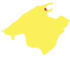
The coastal wetlands of S’Albufereta are one of the natural treasures of the Bay of Pollença, thanks to their singular landscape and their ornithological and botanical value.
The Nature Reserve covers a surface of 211 hectares, with additional peripheral protection of its surrounding 290 hectares, where certain land use and activities are regulated to prevent unwanted environmental impact.
S’Albufereta was declared a Nature Reserve by virtue of Decree 121/2001 (BOIB Number 130, of 30 October 2001), and four years later it was reclassi�ed as a Special Nature Reserve through Law 5/2005, of 26 May, on the Conservation of Environmentally Important Sites (locally known as the law LECO). The S’Albufereta Natural Resource Management Plan was also approved by means of the Government Council Resolution of 19 October 2001 (BOIB Number 130, of 30 October 2001). Yet the site had already been protected by legislation years earlier, thanks to its declaration as a Natural Area of Special Interest in 1991, by virtue of Law 1/1991, of 30 January, on Natural Spaces and Urban Regulation for Areas of Special Protection of the Balearic Islands (locally known as the LEN).
S’Albufereta also forms part of the Natura 2000 Network, an initiative designed to contribute to the conservation of plant and animal species and their natural habitats in protected natural spaces around Europe.
| Area |
211.42 hectares |
| Telephone |
(0034) 971 892 250 |
| Location |
View Map |

The Llevant Peninsula Nature Reserve
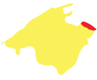
With a protected surface area of 1671 hectares, the Peninsula de LLevant Natural Park covers much of Artà’s mountain range (Muntanyes d’Artà) and includes the highest peaks of the Serres de Llevant (Puig Morei which stands at 564 m; Puig des Porrassar at 491 m; and Puig de sa Tudossa, at 441 m).
The Nature Reserves of Cap de Ferrutx and Cap des Freu, which are located in the municipal areas of Artà and Capdepera, comprise two areas of coastal cliffs at the northern end of the Península de Llevant.
Both the Park and the Reserves were officially listed as such by virtue of Decree 127/2001, of 9 November (BOIB, Official Gazette of the Balearic Islands, Number 140, of 22-11-2001). The limits of the area were later modified by Law 10/2003 of 22 December, on Tax and Administrative Measures. This natural area forms part of the European Union’s Natura 2000 Network, as both an Area of Special Protection for Birds and a Site of Community Interest.
| Area |
1671 hectares |
| Telephone |
(0034) 971 829 219 |
| Location |
View Map |

Mondrago Nature Reserve
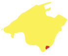
The Mondragó Natural Park is located in the south of Mallorca, in the municipal area of Santanyí, and has a surface area of 766 hectares.
While 95 hectares of the Park are public property, the rest of the park sits on privately owned land and estates, which, often divided into plots, are generally occupied by extensive dry crop cultivation. Mondragó was declared a Natural Park in 1992.
It is also a Natural Area of Special Interest (ANEI) and forms part of the Balearic contribution to the Natura 2000 Network as an Area of Special Protection for Birds and a Site of Community Interest (SCI).
Centuries of agricultural and livestock activity have undeniably shaped and defined the landscape of this area. The many architectural features found here include dry stone walls and the rustic sheds that served as temporary shelters for those who cultivated the poor fields, the rotes. These structures are often made of beams or bear a conical roof, locally known as curucull. Less common are the stone hillside terraces, which sit alongside streambeds and in gullies. Other traditional structures, such as waterwheels, irrigation ditches, water collection ponds and cisterns, are associated with the use of water.
Here there are also constructions that bear witness to the use of the forest. These include charcoal mounds, the charcoal makers’ sheds and lime kilns, as well as other features, such as slipways for boats, sandstone quarries, small defence towers and smugglers’ hiding places.
The name of S’Amarador evokes a past use of the ponds as retting sites, where bundles of flax and hemp were submerged for different lengths of time to attain plant fibres. Tree trunks were also submerged here, making them more resistant, for later use as construction materials in boats and as beams for houses.
| Area |
766 hectares, of which 95 are publicly owned and the remaining hectares are in private hands. |
| Telephone |
(0034) 971 181 022 |
| Location |
View Map |

The Cabrera Archipelago Maritime-Terrestrial National Park
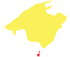
The Archipelago of Cabrera National Park is situated to the south of Mallorca ten nautical miles from the nearest Majorcan port.
The protected area covers 10.021 hectares of which 8.703 is marine based the rest being the small islands that form the archipelago: Cabrera Gran, Illa des Conills, Na Redona, Illa des Fenoll, Na Plana, Na Pobra, L’Imperial, Na Foradada, L’illot Pla, L’Estell de Fora, L’Estell d’en Terra, Es Carabassot de s’Estell d’en Terra, L’Illa de ses Bledes, L’Esponja, L’illot de na Foradada, L’Estell de s’Esclata-sang, L’illa de ses Rates, L’Estell des Coll and L’illa de l’Olló.
The archipelago was declared a National Park on the 29 april 1993 (Law 14/1991). In 1993 an edict approved the site as one of outstanding natural resources (PORN) and in 1995 (Royal Decree 277/1995) came into being the first plan for public use and management (PRUG) revised and ratified in 2006 by the Balearic Government.
Finally in 2001 (Royal Decree 941/2110) the plan for subdividing and regulating activities was approved, commonly known as the fishing plan. Apart from this the Cabrera Archipelago is also part of a specially protected area for birds (ZEPA) and an area of important marine life (LIC). As such it is included in the Nature Network 2000 formed by the European Union. In 2003 it was declared an area of special protection and importance to the mediterranean (ZEPIM).
| Area |
Terrestrial - 1,318 hectares. Maritime - 8,703 : Total - 10,021 |
| Telephone |
(0034) 971 177 645 / (0034) 630 982 363 |
| Location |
View Map |

Sa Dragonera Nature Reserve
Sa Dragonera Natural Park is made up of three islets, Illot des Pantaleu, Sa Mitjana and Sa Dragonera.
With a land surface of 274 hectares, the entire Park, along with a considerable marine area, has been declared a Site of Community Importance (SCI) and an Area of Special Protection for Birds, thus also forming part of the Natura 2000 Network.
Located just off the south-western coast of Mallorca, Sa Dragonera is separated from the main island by a small channel with a width of 800 m and a maximum depth of approximately 15 m.
The road to the conservation of this Park was not easy. In fact, the Park’s protection largely owes itself to the heavy pressures of the local people, who fought against attempts to develop the island in the 1970s. As a result, Sa Dragonera has become a symbol of Balearic conservationism. In 1987, the Consell de Mallorca purchased the island, which was declared a Natural Area of Special Interest until it finally became a Natural Park in 1995.
| Area |
Sa Dragonera (274 hectares) Sa Mitjana (0.29 hectares) Es Pantaleu (2.39 hectares) Maritime Area (634.28 hectares) Total - 908.66 hectares |
| Telephone |
(0034) 971 180 632 |
| Location |
View Map |
Schedule
The Park is open to visitors all year round, from 10 am to 5 pm between 1 April and 30 September, and from 10 am to 2:30 pm during the rest of the year.